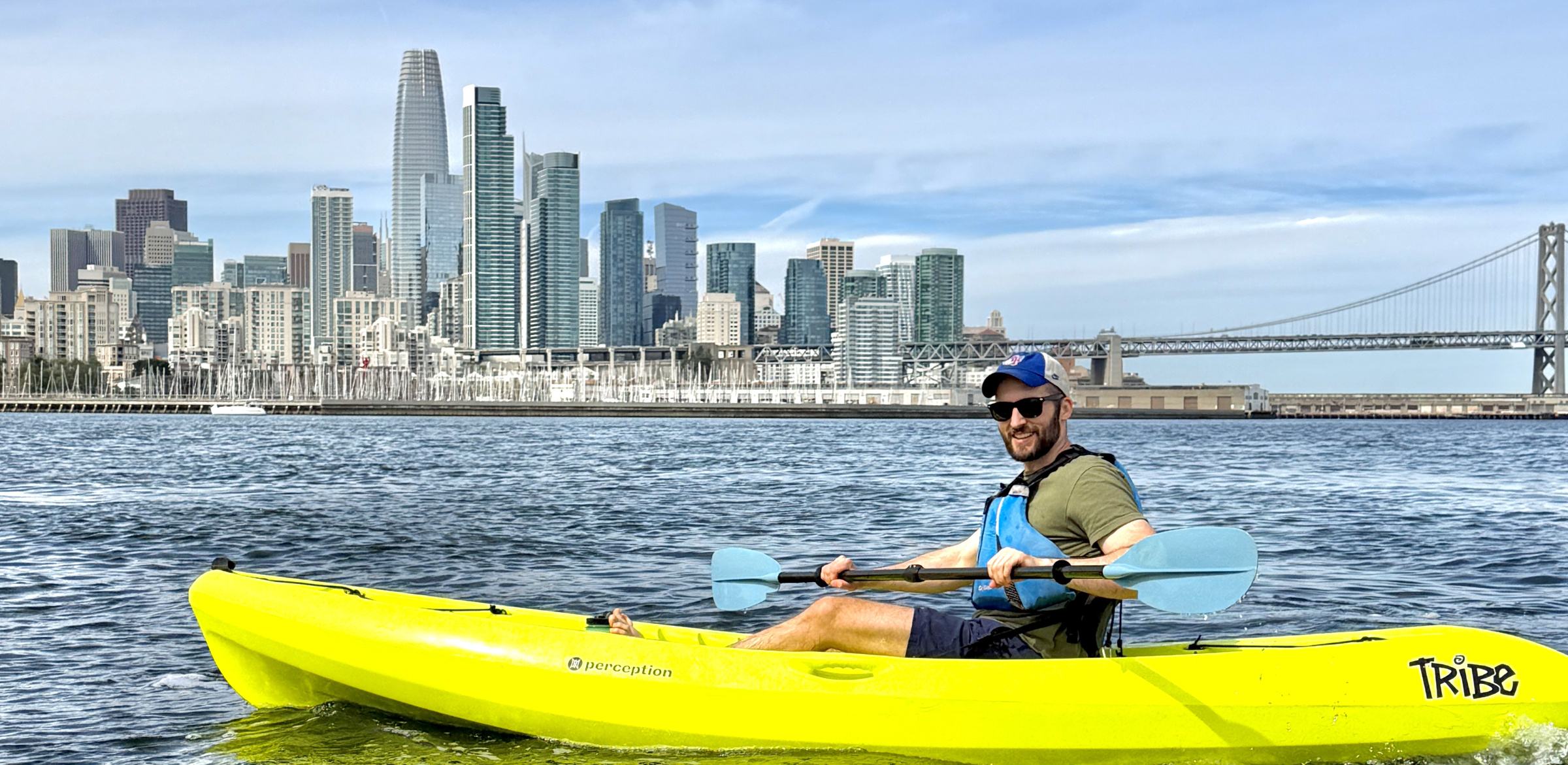
A paddler in a yellow sit-on-top kayak on flat water, with the San Francisco downtown skyline and the Bay Bridge behind

Plan the paddle, then go

Paddling the San Francisco Bay

How to time tides, read wind and choose routes from Crane Cove.

Crane Cove is one of the best launch spots in San Francisco: protected water, easy access, skyline views and wildlife sightings. If you’re new to the area, this page shows how to time tides, read wind and choose routes - plus when it’s smarter to join a lesson or tour for hands-on coaching.

Mission Creek is an awesome put-in for convenient access to McCovey Cove or the Bay Bridge. The calm water of the creek is also an excellent training ground for new paddlers not yet comfortable heading into the greater Bay. You can launch from the Boathouse.

Tides & currents

The currents in San Francisco Bay are legendary. Twice a day, Pacific water surges in under the Golden Gate then drains back out, creating powerful flood and ebb flows that can overwhelm even strong paddlers. If you’re new to the Bay, nothing substitutes for hands-on instruction.

Aim for slackThe best time to paddle is slack tide - the brief window as the tide transitions and current is at its lowest. As a rule of thumb, plan for about an hour either side of each high and low.
Know your limitsUse our route map to see recommended zones. Do not pass the warning markers unless you are very confident you can handle the current now, and on your return when the direction reverses.
Use a local tide appSet it to Potrero Point, our local reference. We like Tides Near Me for quick checks - or use our .

Before you launch

Plan your paddle around the current

Tell it when you want to get on the water and when you want to be back. It reads the Potrero Point predictions and tells you which way to head first.

Wind & weather

Always check conditions first. Use our 24/7 Crane Cove webcam below to see what the water is doing in real time. If it looks rough on camera, don’t launch - or stay in the most protected water.

What to look for: wind in the trees, whitecaps on the water, and other paddlers out and about. Do not attempt to go out if conditions are not favourable.
Wind is the biggest factorIt unsettles balance and makes forward progress tough for both kayakers and stand-up paddlers.
Feather your paddleTurn the blade edge-on to the wind during recovery to cut resistance.
On a SUP, get lowerIf wind builds, drop to your knees, or go prone, to lower your profile and stay stable.
Watch for chopWind creates a bumpy surface layer. When you see whitecaps on the webcam, big or small, expect challenging conditions.
Practise on glassy daysBeginners should aim for calm, glassy water to work on stance, strokes and turns before venturing farther.
Use a wind appWe check Windy, then confirm with the webcam right before heading out.

Safety & local rules

On the water

The rules printed down the side of the map, and the ones that keep people out of trouble here.

Beginners stay in the coveCrane Cove is protected and it is generally the calmest water on the Bay. Learn your boat here first.
Stay close to the shorelineWe suggest staying around 30 feet from the shoreline and piers. Never paddle out into open water.
Use the shoreline and piers as shadowsThey break both the wind and the current. That is why every route on the map hugs them.
Aim your nose at the middle of a pierNever at a point past the end of one. Aim past the end and the current takes you past it.
Stop at the edge of every pierLook at the conditions on the other side before you commit to them.
Don’t cross an open bay or coveUnless you are certain the water is calm.
Come home with the current at your backPlan the paddle around it. The direction reverses while you are out.
If it is windy, consider another dayAnd if you do go, do not go far from Crane Cove.

Local rules

No swimming at Crane CoveWading in the near-shore buoyed area only. These are Port of SF rules for the beach.
Wear a PFDCalifornia requires a USCG-approved life jacket on board for every person, and under-13s must wear one while underway. We recommend everyone wears a PFD on the Bay.
Give working vessels spaceKeep about 100 feet from vessels and the dry dock. Tugs, ferries and ships can’t manoeuvre like you can. Cross behind them, not ahead, and stay along the shoreline when unsure.
EmergenciesUse VHF Channel 16 or dial 911. The USCG monitors Channel 16; the Sector SF search-and-rescue desk is 415-399-3530 as a phone backup.

Routes

New paddlers often head straight out into open water from Crane Cove to try their new gear. We see it all the time. Our suggestion: don’t. We have mapped the waterfront instead, from the Bay Bridge south to India Basin, graded the way a ski map grades runs. Open it full size for every point of interest.
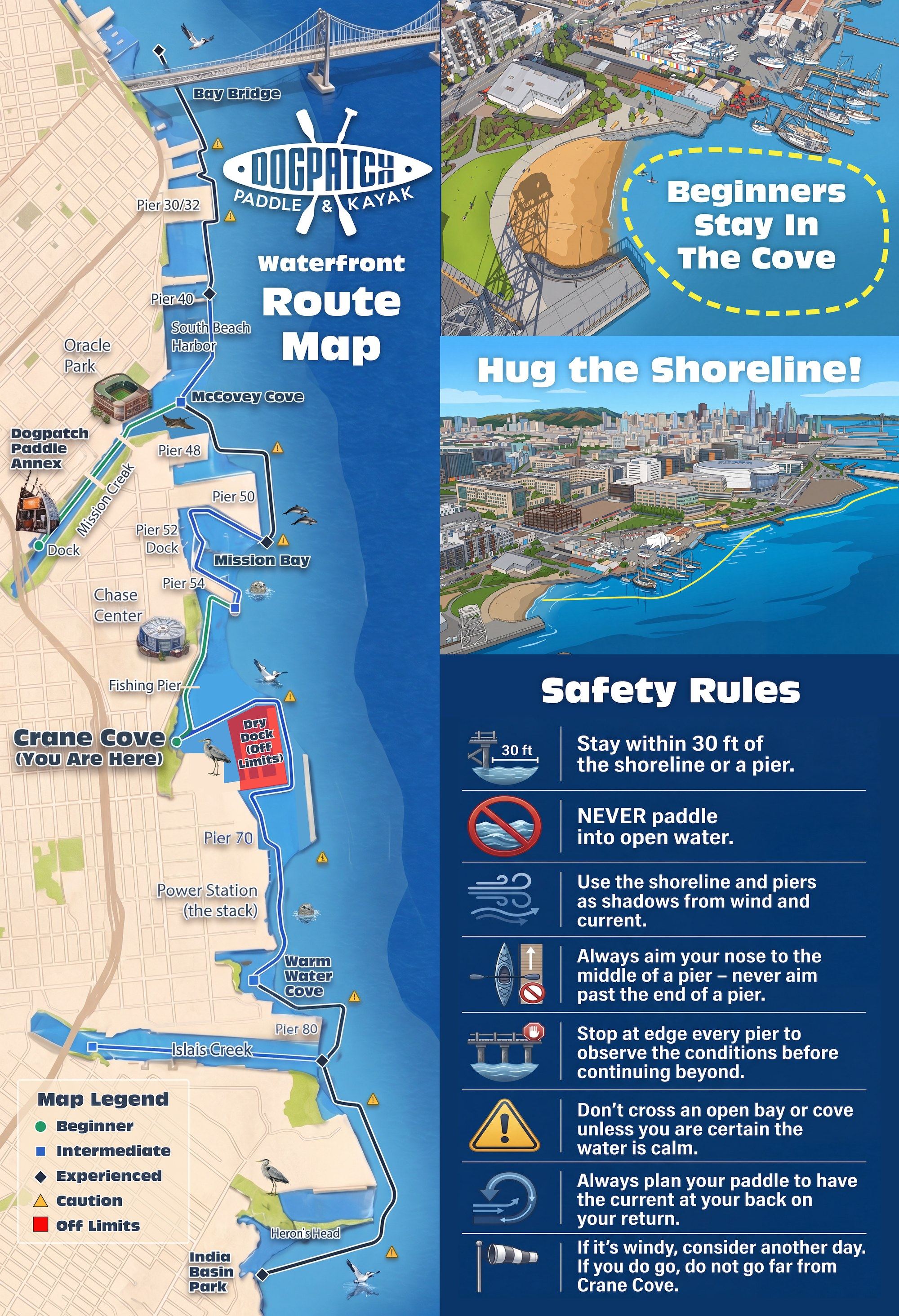
Dogpatch Paddle route map of the San Francisco waterfront, from the Bay Bridge south to India Basin, with beginner, intermediate and experienced paddling routes marked along the shoreline, the Crane Cove launch point, and the dry dock marked off limits. Open the full map
Map key
  • Beginner
  • Intermediate
  • Experienced
  • Caution
  • Off limits
Open the full map

Beginner

Green on the map. Each of these stays in a cove or hugs the shore the whole way.

Crane CoveThe safest place to practise, and generally the calmest water on the Bay. Our summer campers learn figure eights and turns here.
Crane Cove to Pier 54Stick close to the shoreline the whole way: past San Francisco Boat Works and Mission Rock Resort, under or around the Agua Vista fishing pier, on to Pier 54, where the map turns blue.
Mission Creek to McCovey CoveLaunch at the Boathouse and paddle the creek out past the houseboats, under the 4th and 3rd Street bridges. Calm water, and the best training ground for anyone not ready for the open Bay.

Intermediate

Blue on the map. For paddlers building confidence in relatively calm conditions.

Pier 54 to Pier 52 and 50Flat water, slack tide, clear days only. Do not pass the edge of Pier 54 unless it is glassy with no current either way. Then turn west, follow Pier 54 in to Pier 52, and hug the pier round to the dock for a rest or an extraction.
Cape Horn and Cape HudsonHead close along Pier 50 to the edge and poke out into the shadow of the massive war ships. Do not pass the end of the pier, where the map turns black. Peek at it, take a photo, and trace your steps back.
Crane Cove to Warm Water CoveOut towards the dry dock, north of the warning buoys, to the edge that opens into the Bay. The current builds here, so plan for slack or a tide flowing your way. Hug the pier south past the dry dock, back in to the shore, then on to Warm Water Cove past the Stack. The ruins on this side we call Pompeii, and the sunken pilings will puncture a craft at any tide.
McCovey Cove to Pier 40North along South Beach Harbor. Spur into the harbour for the sea lions baking on the docks. Pier 40 is where the map turns black: everything north of it, up to the Bay Bridge, is experienced only.

Experienced

Black on the map. Check the tide and wind sections above before passing a checkpoint.

Crane Cove to McCovey CoveThe open passage, and the reason the creek route starts at the Boathouse. Round the north side of Pier 50 past the Cape Horn and Hudson, where the channels put real force behind the current. Plan it on slack or a tide that favours you, then head in to McCovey Cove and up the creek.
Islais CreekAround Pier 80 and into the creek, if you have the gumption and the conditions. Heavy ship traffic, and both tide and wind run harder in the creek. The map turns black at Pier 80 and blue again inside the creek, so it is the corner that earns the grade. The dock is a rest stop or an extraction point.
Also on the mapTwo more experienced runs are marked and not written up here: Pier 40 north to the Bay Bridge, and Warm Water Cove south past Heron’s Head to India Basin Park. Talk to us at the shop first.

News from the water

Twice a month: what is on at Crane Cove and Mission Creek, and what is coming up next.

No spam. Unsubscribe any time.

HomeKayak & SUP RentalsLessons & ToursGiants GamesSaunaPrivate EventsYouth CampsEquipment StorageGift Cards

Plan Your Visit

Preparing to PaddlePaddling in San FranciscoQuestionsCancellations

About

Our StoryCrane Cove ParkMission Creek BoathouseJournalContact